
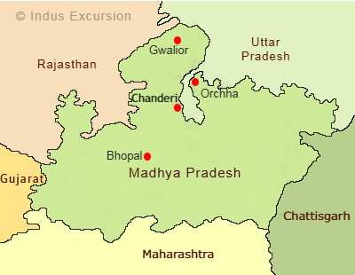
Chanderi lies in Ashok Nagar district of Madhya Pradesh. Basically it lies in northern part of state at the border of Malwa and Bundelkhand region. Similarly it is close to state border of Madhya Pradesh and Uttar Pradesh state thus its nearest railway station is at Lalitpur town, which is part of Uttar Pradesh state. Its road connectivity is very good with all parts of state. Majority of tourists arrivals are noticed through train journey and from Lalitpur railway station. Tourists on multiple destination tour often comes via Orchha, Bhopal, Sanchi and Khajuraho.
Within Madhya Pradesh, Chanderi city lies in north-west of Bundelkhand region, close to state border of Madhya Pradesh and Uttar Pradesh state. Railway line connecting Delhi to Bhopal, passes through Lalitpur railway station thus mostly tourists use this track for reaching Chanderi. This city is located close to Betwa river. Please check the below given connectivity details:
| Through Airports | Through Railway Stations | Through Destinations |
| Bhopal Airport = 250 km / 05:00 hr | Lalitpur Railway Station = 30 km/45 min | Orchha = 100 km / 02:30 hr |
| Khajuraho Airport = 230 km / 05:00 hr | Bhopal Railway Station = 250 km / 05:30 hr | Sanchi = 180 km / 04:00 hr |
| Gwalior Airport = 250 km / 05:30 hr | Jhansi Railway Station = 120 km / 03:00 hr | Jhansi = 120 km / 03:00 hr |
| Khajuraho = 240 km / 5:30 hr | ||
| Panna National Park = 240 km / 05:00 hr | ||
| Bhopal City = 250km / 05:20 hr |
 9202337070